


LeaserBiM is a young vibrant organization providing solutions in domains of Geospatial Services (GIS, CAD and LiDAR,) and Engineering Services to the global market since 2022. We are a team of passionate tech enthusiasts dedicated to delivering top-notch IT solutions. has been consistently providing its client switch cutting edge services while were completely geared up for the next level in Engineering and Geo-metrics Services domain . We offer 1.IndoorService,LiDAR,MobileLiDAR,ORTHO,GIS,CAD,PLSCAD,BIM,RemoteSensing,etc. 2. Outdoor Services in industries such as forestry ,oil & Gas, agriculture, railway & road and networking from multisensory data fusion for small sites to state- wide mapping programs. Our staffs include surveyors, engineers, as well as mapping scientists and GIS specialists. No job too small or large, we provide our services to independent geometrics companies, government bodies and transport authorities. The information is provided in a format that is ready to integrate into various types of GIS and CAD system at our clients utilize.

Leaserbim provides professional geospatial services in strict adherence to the highest ethical and technical standards. We understand that each of our client's needs are unique, however they all require timely, technically sound and cost effective solutions. Our standard business practice is to work with each client by clearly defining projects cope and corresponding requirements to develop a solution that is right on target

To offer universal and innovative solutions for integrating spatial information into the systems and processes of organizations.To be considered among the premier engineering, design and geospatial data processing service companies in the energy ,oil and gas ,forestry, pipelines and urban planning industries by our customers ,competitors and agencies. We strive to maintain and promote the proper balance between safety, quality and financial performance while people and the environment remain our most valued and highest concerns.

Leaserbim strength lies in its core of competent, highly qualified, trained and experienced geoscientists, and skilled computer and software professionals known for development of innovative program to provide cutting edge technology based services.
We offer a wide range of geospecial services to meet your business needs.

Tailored software solutions to streamline your business processes.

Scalable and secure cloud solutions to enhance your business operations.

Comprehensive security solutions to protect your digital assets.
Expert advice to help you navigate the complex IT landscape.
Data-driven insights to help you make informed business decisions.

Comprehensive IT management to keep your systems running smoothly.
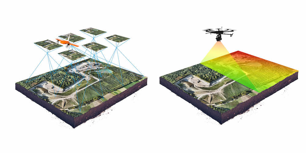
We have been at the forefront of revolutionizing the way spatial data is collected, analyzed, and utilized across various industries. Through our advanced Lidar technology, we have successfully conducted high-precision 3D mapping projects, providing our clients with detailed and accurate geospatial information for better decision-making.

A cadastral map is a detailed map that shows individual land parcels' boundaries, ownership, and other related information. In India, these maps are used for land management, urban planning, resource allocation, and survey purposes.

With Lider technology,we can capture detailed 3D information, including the position , height, and shape of power lines.This data aids in the analysis of line sag,clearance issues,and vegetation encroachment,allowing electrial departments to take proactive measures to prevent outages and improve system performance...

GIS (Geographic Information System) classification is the process of grouping or categorizing geographic or spatial data into meaningful classes or categories based on specific attributes or patterns. It is widely used in remote sensing, land use mapping, environmental monitoring, and urban planning to interpret and simplify complex spatial datasets...


Get in touch with us to learn more about our services or to request a consultation.
Head Office
CR67+5W8, Khantapada, Balasore, Odisha 756043Branch Office
1/46,Work2Zone, VijayaEnclave, Dashrath Puri, New Delhi,110045Email:project@leaserbim.com
Phone: (+91) 6370056597